Farm Water Management: More Than Just Land Levelling
The term ‘Water Management’ is used in precision agriculture to define a category of technology solutions that assist farmers in managing the impact of water on their fields.
While many farmers consider ‘water management’ and ‘land levelling for irrigation’ as synonymous, in reality, the range of water management applications and technologies is far more holistic, including solutions for:
Ponding
Erosion
Waterlogging
Irrigation
From irrigated to dryland farming, let’s explore how growers can mitigate a range of issues by optimising the impact of water on their fields.
Waterlogging
We know waterlogging, on average, decreases crop yield by 32.9%. We also know prevention is better than a cure.
Subsurface drainage is the practice of placing perforated pipe (or drainage tile) at a specified grade (slope) at some depth below the soil surface. Excess water from the crop root zone can enter the pipe through the perforations and flow away from the field to a gully or other outlet.
One of the earliest applications of the Laserplane technology (now part of Trimble) in the late 1960s and early 1970s was to control the placement of drainage tile beneath the fields of the Mid-West of the US.
Trimble has since expanded their technology to include WM-Drain®, a solution that streamlines the survey, analysis, design, installation, and mapping steps of surface and subsurface drainage.
With WM-Drain, growers can carry out all drainage operations with one on-the-go system, improving root zone development by removing waterlogging to optimise nutrient absorption and minimise soil erosion, field compaction and plant stress.
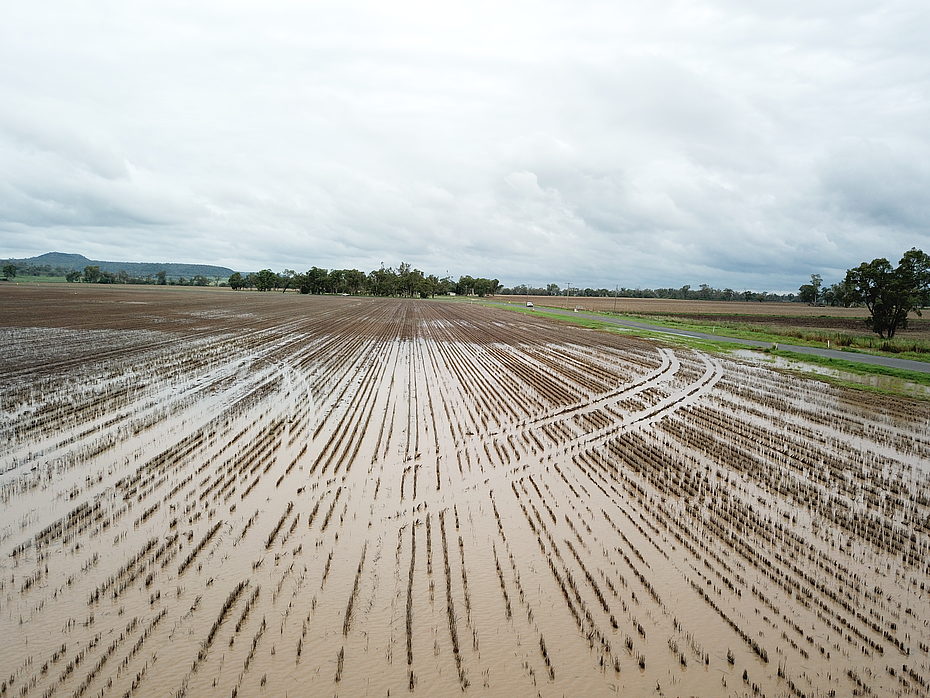
Ponding
If water pools in your fields for over 24 hours after rainfall or irrigation, causing a loss in productivity, you need a water management solution.
While, traditionally, planar laser levelling has been used to manage this, we now often look to Optimum Surface Landforming to solve ponding and drainage issues.
Optimum Surface Landforming involves minimally modifying field topography by cutting and filling to a predetermined 3D surface using GPS machine control.
We utilise the world’s leading system for farm earthworks design, OptiSurface™, which calculates the optimised field topography to solve water management problems.
When compared to planar laser levelling, our land forming service can save up to 80% on earthworks costs because the aim is not to totally level the surface but to optimise.
Using OptiSurface’s advanced technology, our team can help you improve drainage and reduce surface ponding.
Erosion
Soil erosion in cropping land is caused by water travelling across the surface too quickly. As well as causing a significant reduction to the productive capacity of the soil it also causessedimentation in downstream areas, reduces water quality and leads to operational delays when working the field.
Reducing erosion in the field is best undertaken through a multifaceted approach of:
Maintaining soil coverage,
Implementing strip cropping
Designing grassed waterways
And implementing contour banks (also known as grade banks)
The purpose of the contour bank is simple – to slow the rate by which the water travels across the field and to then move it into a defined waterway.
These contour banks and waterways need to be carefully designed to ensure they work based on the topography, soil type, rainfall events, and operations. The banks and waterways will be often built by dozers, scrapers or graders utilising GPS equipment.
By utilising OptiSurface, our team can provide advice and designs to that match your specific requirements.
Irrigation
In 2020-21, ~1.9 million hectares of agricultural land was irrigated in Australia, with surface irrigation as the most common irrigation technique.
Regardless of your irrigation method, we have the technologies to allow you to optimise your operation, including:
Laser grading solutions
For level or simple grade solutions, our laser-based solutions remain an economical way to ensure an even placement of water across your fields.
GPS grading
The use of GPS allows the field designer a lot of additional design flexibility that cannot be matched by the traditional laser levelling systems. The Trimble Field Level II system can be utilised across a wide range of irrigation design types including:
- Bay,
- Level basin,
- Furrow or
- Bankless.
Modern design packages such as OptiSurface allow the designer to work with you to optimise your irrigation design but also reduce the amount of earth moved, significantly reducing the cost.
Centre pivot & lateral irrigation
Undertaking OptiSurface designed earthworks underneath a lateral or centre pivot irrigation system has been proven to produce a more consistent penetration of the moisture into the soil and reduce ponding.
The reduction in ponding will also prevent the pivot wheels from bogging, therefore reducing manual intervention and energy costs.
With 40 years as an industry leader in landforming and water management, at Vantage BMS, we know that a key part of making any of these applications work is an in-depth understanding of what the topography, soil type, soil depth of field, its challenges, and its potential.
Our experienced team can undertake precise field surveys and create an optimal field design. We then use our range of scraper blades to make it happen with minimal topsoil disturbance and earthworks costs.
By combining a range of industry-leading precision ag systems from Trimble Agriculture, OptiSurface, and our range of scrapers, our expert team can recommend a right-fit solution to reduce ponding and better manage your subsurface drainage.
Learn more about our water management solutions and get our Beginner’s Guide to Landforming.